


A More Meaningful Accuracy Radius for IP Geolocation

Get Unlimited Access to IPinfo Lite
Start using accurate IP data for cybersecurity, compliance, and personalization—no limits, no cost.
Sign up for freeEvery IP geolocation answer comes with two things: a point on the map, and how far from that point the user might be. The first gets the attention. The second, the accuracy radius, often decides what you do next: trust the city or fall back to the country, flag the login or let it through.
Starting Nov. 16, IPinfo's accuracy radius is calibrated: for any IP, there's a 68% chance its user is within the radius we report. We check it every week against real-world GPS locations the model has never seen.
When we set the target, the obvious question was, why not promise 100%? That’s because every IP has a few devices that show up far from the rest: travelers, VPNs, phones roaming on a foreign SIM. A radius that had to include them would be set by those few, most IPs would get radii of thousands of kilometers, and you could no longer tell a precise IP from a vague one. So we chose the standard your phone GPS already uses. The blue circle around your position in a map app is a 68% radius too.
What the Radius Describes
The radius describes the IP. Some IPs are used in one place: a home broadband line, an office, a server. Others are shared by thousands of people and reassigned across a region, like most mobile carrier IPs. Both can have the right location. Only one has all its users close to it. The radius now tells you which kind you're looking at.
How We Calculate It
The radius draws on the same evidence behind our locations: how spread out real devices are on an IP and its network, measurements from ProbeNet, our internet measurement network of 1,300+ points of presence, and the kind of network the IP belongs to. A model turns that evidence into one number, and we check it every week against real-world GPS locations it has never seen.
The Result
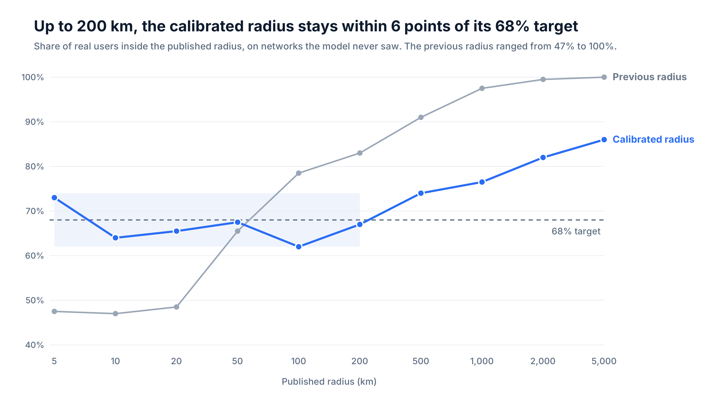
On networks the model never trained on, the radius stays close to its 68% target from 5 km to 200 km, where most IPs fall. For the technical details, see our community post.
What You'll See
The underlying IP locations aren't changing as part of this update. What changes is the accuracy radius associated with them:
- Mobile carrier ranges get larger radii, because their users are spread out. If you use 200 km as a cutoff, more mobile IPs will cross it.
- Fixed-line ranges barely move, and many get tighter.
- Servers we can measure with ProbeNet keep radii of a few kilometers.
- Locations themselves don't change. Only what we tell you about them does.
How Teams Use the Radius
The radius turns a location into information you can act on. Teams that use IPinfo use it in four ways.
To decide whether to trust a location. Ad platforms and content teams use the radius to choose between city-level and country-level decisions. When the radius is small, they target the city or show localized messaging. When it’s large, they fall back to the region or country instead of guessing.
To weigh a mismatch. In fraud prevention and identity verification, the distance between a user’s stated address and their IP location is a common risk signal. The radius tells you how much that distance means. A 300 km gap on an IP with a 10 km radius is strong evidence. The same gap on an IP with a 1,000 km radius tells you very little.
To draw honest maps and reports. Analytics and security teams show small-radius IPs as points and group large-radius IPs by region or country, so a dashboard doesn’t suggest more precision than the data has.
To set cutoffs from their own traffic. The right threshold depends on who your users are. A mobile-heavy audience has more large radii than a broadband or business audience. Look at how the radius is distributed across your own IPs before you set a rule.
Making More of Our Evidence Visible
IPinfo has always known more about an IP than a single row could show. We know how many devices use it and how far apart they are. We know which router it sits behind and how fast our probes reach it. Until now, most of that stayed inside our pipeline. It shaped the location we published, but you only saw the result.
The calibrated radius changes that. It turns all of that evidence into one number with a stated meaning, so you can act on what we know, not just on what we concluded. It's the same idea behind IPinfo Places, which shows the venue behind an IP, and behind ProbeNet Live, which lets you run our measurements yourself. Not just where an IP is, but how sure we are and why.
The radius field is available on IPinfo Plus, Max, and Enterprise Geolocation Extended datasets. To see how it changes your traffic, talk to our team.
Share this article


About the authors

Daniel Quandt leads the solutions engineering team at IPinfo, where he helps customers get the most out of internet data. Before IPinfo, he worked in data science in the hospitality industry.

As the product marketing manager, Fernanda helps customers better understand how IPinfo products can serve their needs.